
Keyword
Earth Science | Oceans | Ocean Optics | Ocean Color
89 record(s)
Type of resources
Topics
Keywords
Contact for the resource
Provided by
Formats
Update frequencies
Status
draft
-
This record contains data collected from the near-water surface sampling site off the Lucinda Jetty, as part of the Lucinda Jetty Coastal Observatory. Sample collection began the 9th of January, 2014. The data can be used for Ocean Colour sensor validation. Parameters measured include the absorption coefficients of the particulate and dissolved components of the water column and the phytoplankton pigment concentration and composition.
-
ESRI grid showing ocean primary production extracted from global observations of ocean colour data from the moderate resolution imaging spectroradiometer (MODIS). This grid has been produced by CSIRO for the National Oceans Office, as part of an ongoing commitment to natural resource planning and management through the 'National Marine Bioregionalisation' project. Chlorophyll accuracy is about ± 20%.
-
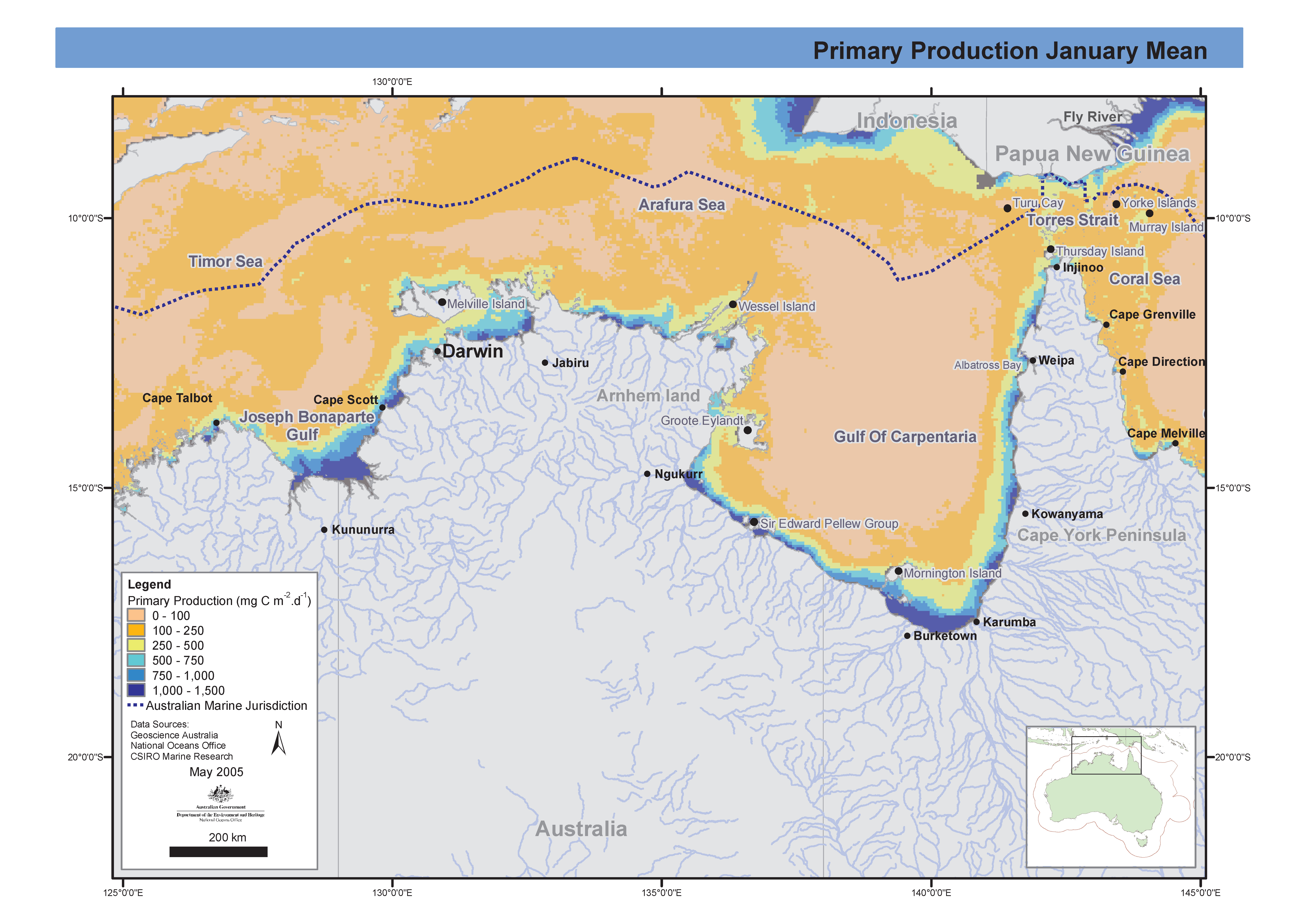
Set of two maps showing mean seasonal (wet/dry) ocean primary production in the Northern Marine Region extracted from global observations of ocean colour data from the moderate resolution imaging spectroradiometer (MODIS). These maps have been produced by CSIRO for the National Oceans Office, as part of an ongoing commitment to natural resource planning and management through the 'National Marine Bioregionalisation' project.
-
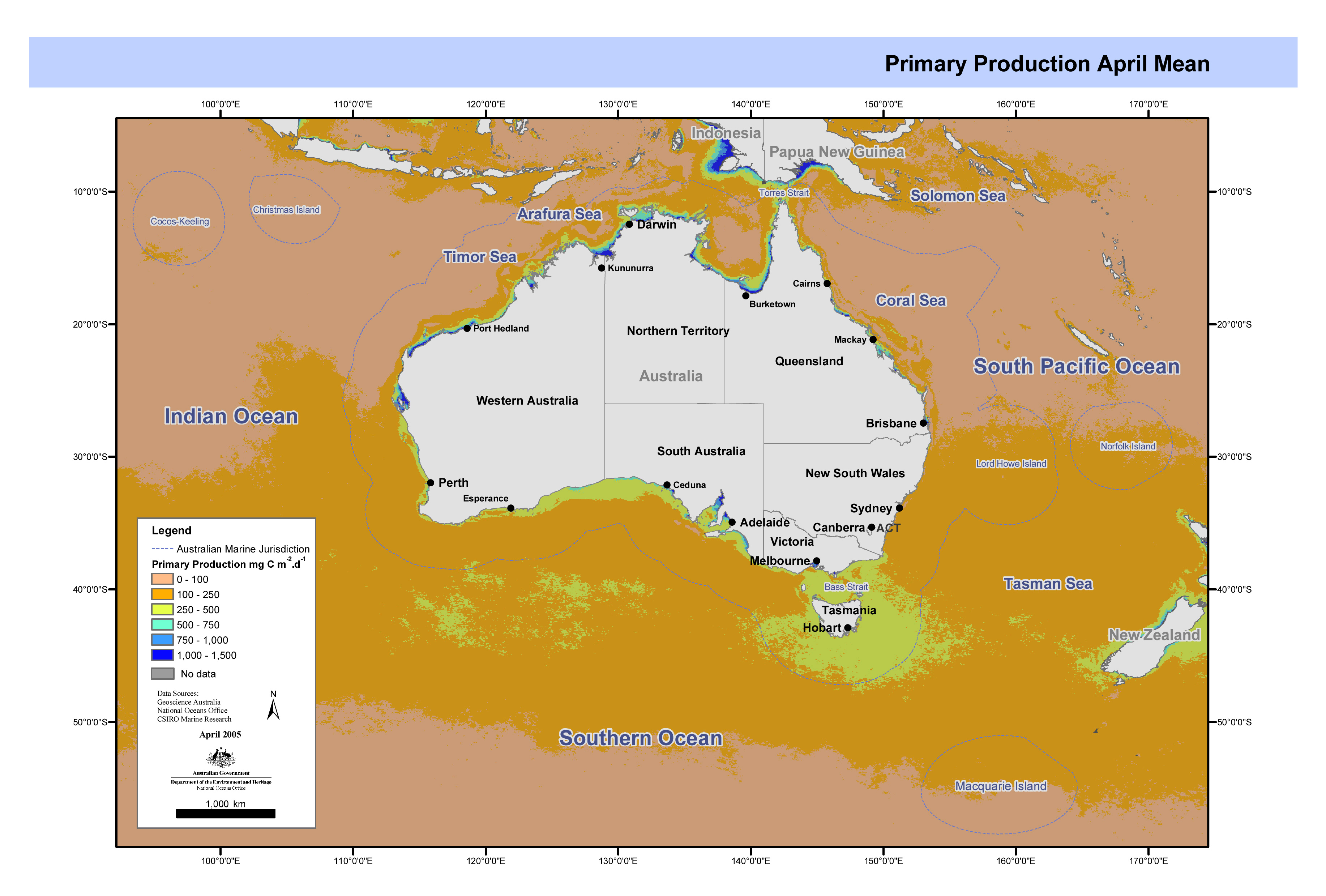
Set of maps showing ocean primary production in the Australian region extracted from global observations of ocean colour data from the moderate resolution imaging spectroradiometer (MODIS). These maps have been produced by CSIRO for the National Oceans Office, as part of an ongoing commitment to natural resource planning and management through the 'National Marine Bioregionalisation' project.
-
This data set contains the MODIS Aqua ocean colour satellite data from the period December 2002 to January 2004. The data are received as monthly composites, with a 4 km resolution, and are constrained to the region between 90E and 180E, and 10N to 60S. The data set is a level 3 product, where the chlorophyll accuracy has been assessed and the uncertainties in the product well established in a systematic and statistically robust way representing global rather than regional conditions. The data was sourced from http://modis.gsfc.nasa.gov/. The data are in hdf format, and consist of 96 files totaling approximately 850 MB. The Moderate Resolution Imaging Spectroradiometer (MODIS) administered by NASA Goddard Space Flight Center, is a 36-band spectroradiometer measuring visible and infrared radiation and obtaining data that are being used to derive products ranging from vegetation, land surface cover, and ocean chlorophyll fluorescence to cloud and aerosol properties, fire occurrence, snow cover on the land, and sea ice cover on the oceans, from a continuous global coverage every 1 to 2 days. The first MODIS instrument was launched on board the Terra satellite in December 1999.
-
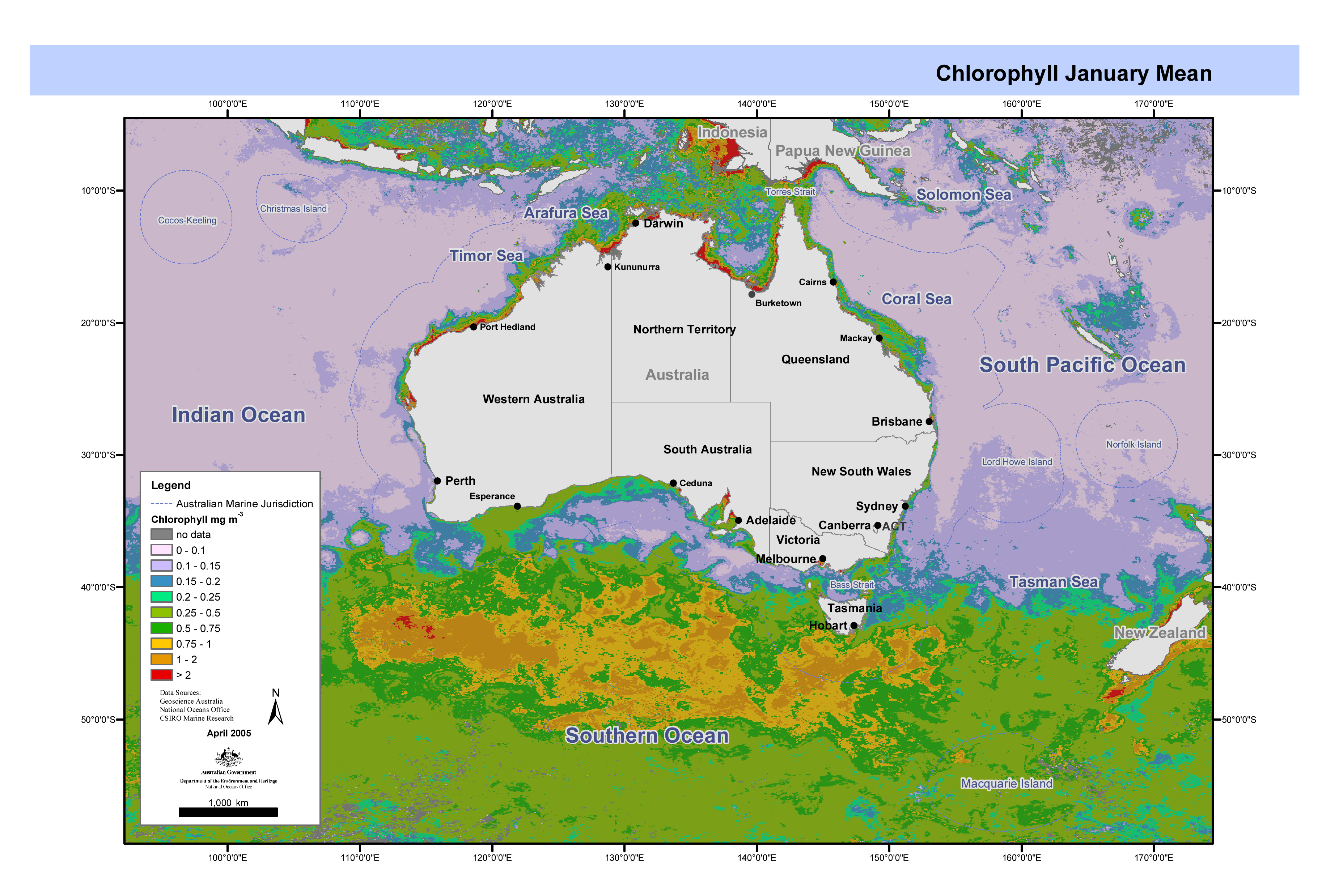
Set of 4 maps showing quarterly means of ocean colour data from the moderate resolution imaging spectroradiometer (MODIS). These maps have been produced by CSIRO for the National Oceans Office, as part of an ongoing commitment to natural resource planning and management through the 'National Marine Bioregionalisation' project.
-
This is a selection of the MODIS 8 day mean level 3 mapped 8 day mean ocean products at the two highest resolutions available. It spans from July 2002 onwards and will be augmented by newer data from time to time. The source of the data is NASA at the above reference. This data has been reformatted into 3 dimensional, longitude by latitude by time netcdf files for use by researchers in CSIRO. Initially the following products have been selected: chlorophyll, extinction coefficient (K490) and sea surface temperature. The NASA data are also available in various resolutions. The highest two resolution levels have been chosen, with nominal pixel size of 4 and 9 kilometres. A description of the processing carried out by NASA is at http://oceancolor.gsfc.nasa.gov/DOCS/modis_processing_overview.pdf
-
This dataset contains the results from algal bloom surveys in the Swan River, Perth, Western Australia. Aeroplane flights were used to map the extent of the blooms and at the same time, sea truthing of the images were made using an analysis for various pigments and obtaining phytoplankton samples. Four flight periods were made between October 1994 and December 1995, with up to 4 flights a day. The main species studied was the dinoflagellate Gymnodinium.
-
his movie file consists of a series of 8-day composite, 4 km resolution SeaWiFS surface chlorophyll images for the geographical area bounded by 90°E-180°E, and 10°N to 60°S. The data run from September 1997 until March 2001. Pixels where no usable data has been received are represented in black. A colour bar and calendar are included in the movie. Pixels where no usable data were received are represented by black dots. Accuracy is ± 20%. Each scene was captured as a gif image, and then assembled into a movie by Chris Rathbone, CSIRO Division of Marine Research Remote Sensing Group. The composite images were obtained from http://oceancolor.gsfc.nasa.gov/SeaWiFS/ .
-
The Japan Agency for Marine-Earth Sciences and Technology (JAMSTEC) sponsored this research cruise - a circumnavigation of the Southern hemisphere using the World Ocean Circulation Experiment (WOCE) Hydrographic Program (WHP) lines in the southern hemisphere to celebrate the 30th anniversary of its establishment. The research cruise was named "BEAGLE 2003" (Blue EArth GLobal Expedition 2003) and was carried out on RV MIRAI. This is a subset of the Beagle 2003 data set and contains the HPLC pigment and particulate absorption coefficient data collected on leg 3, between Valparaiso, Chile and Santos, Brazil from the 20 Oct to 25 Oct 2003. The data can be used for Ocean Colour sensor validation. Parameters measured on the leg are the concentration of chlorophyll and carotenoid pigments and the absorption coefficent for particulate (a/p) components of the water column. Samples were collected at 11 stations. The data was used primarily to validate ocean colour sensors MERIS, MODIS and SeaWIFs and the SST sensor AATSR. Samples were collected and analysed for pigments and absorption coefficient, particulate.